Tropical Storm Hurricane Gil 2025 formed quickly in the eastern Pacific and became a hurricane on August 1, 2025. The National Hurricane Center followed the storm from its beginning to its peak. Gil started as a disorganized tropical disturbance but strengthened over warm ocean waters. Meteorologists reported winds increasing steadily with better-defined rotation in satellite imagery.
Experts said Gil would be a hurricane in 24 hours, and it was. No watches or warnings were issued as it was over 1,000 miles from the Baja California peninsula. This was the start of a busy period for Pacific storms in late July and early August.
Hurricane Gil 2025 Strengthens and Moves Away from Land
Gil became a Category 1 hurricane on August 1 as conditions were favorable for development. It had 75 mph winds and 991 millibars as it stayed over open water. It was moving 20 mph west-northwest and far from land. Although Gil was strong, it never threatened the coast due to its location. Forecasters said no land areas were in danger from Gil or related storm effects. The NHC was monitoring Gil but expected it to stay far from the ocean. Gil was one of several systems in the Pacific but was alone from populated areas.
Also read: Austin Hill Suspended by NASCAR for Intentional Crash
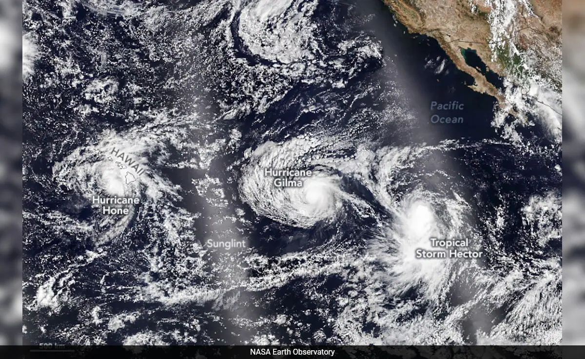
Multiple Pacific Storms Formed During Hurricane Gil 2025’s Lifecycle
Hurricane Gil 2025 wasn’t alone in the Pacific; Hurricane Iona and Tropical Storm Keli formed around the same time. Iona became a Category 3 but weakened before it could get near land. Keli formed soon after with 40 mph winds but was weak and disorganized. None of the storms affected Hawaii or the west coast of North America.
Five systems were tracked in the Pacific during this period, including Hurricane Gil 2025. Meteorologists said it was a busy tropical period. They attributed it to warm sea temperatures and a monsoon trough in the Pacific Basin. All were oceanic. None of the same in the Atlantic. This pattern was expected to continue for a few more days.
Models Showed Consistent Storm Path
Spaghetti models for Gil stayed tight throughout its life, with high confidence in the westward track. Forecasts showed Gil going west-northwest, then slowly west. Meteorologists attributed this to a steady subtropical ridge steering. Although models showed some variation, most were on a safe open water path. Forecasters expected weakening once Gil entered cooler waters and upper-level wind shear.
NHC adjusted intensity forecasts daily with updated satellite data and ocean conditions. Despite the storm’s strength, no indicators of land interaction or deviation from the projected path. Gil’s track was a classic Pacific hurricane pattern, strengthening over warm water, weakening as it went west. This steady track meant no warnings were needed.
Comparisons to Historical Hurricane Gil
The 2025 Gil is similar to Hurricane Gil from 1983, which formed in the eastern Pacific. That storm developed in July, became a hurricane and went west before weakening. It passed near Tern Island before dissipating over open water in early August. The 1983 Gil was stronger up to 90mph, but like the 2025 version, it didn’t impact land.
Meteorologists study past events to understand storm behavior and validate forecast models. Historical comparisons help improve forecasts by showing recurring storm lifecycle patterns in the Pacific. While storms differ in structure and intensity, many share timing, movement and environmental triggers. Gil 2025 followed a lifecycle familiar to forecasters who tracked eastern Pacific activity in previous decades. This allowed quicker recognition of patterns and more accurate forecasts of weakening.
Atlantic Could See Action Soon
The Pacific was busy, but the Atlantic was quiet through July 2025. Forecasters saw a pattern change that could bring activity to the Atlantic in the next few weeks. Long-range models showed warming waters and lower wind shear in the main development region. Tropical waves moving west across Africa became more frequent and offered more opportunities for storms to form.
Gil and other Pacific storms might be the start of a more active period across both basins. Analysts expected tropical development in the Atlantic to increase by mid-August. Forecasters were watching both basins closely for the first signs of new storms. Preparations were already underway in Atlantic coastal areas.
Also read: Deion Sanders Cancer Comeback Inspires Colorado Team
Conclusion: A Storm That Stayed at Sea
Hurricane Gil 2025 was the poster child for the Pacific hurricane season’s early activity. It grew fast but stayed far away from any populated landmasses. Hurricane Gil 2025 caused no damage, no evacuations, and still offered valuable insights into storm tracking. As Gil dissipated, attention turned to the Atlantic, where conditions were steadily improving for development.
The Pacific’s burst of activity may only be the start of a busier tropical season ahead. Gil reminded us to always monitor and forecast accurately. Even distant storms like Gil deserve to be watched and responded to.